3 Empirical strategy
3.1 Introduction
In this section, we will discuss the empirical strategy for assessing road quality in South Africa using images from Google Street View. One of the main advantages of using Google Street View images is the cost-effectiveness of the approach. Compared to traditional remote sensing techniques, such as aerial or satellite imagery, using Google Street View images can provide a more cost-effective way of obtaining high-resolution images of roads.
In a country like South Africa, where the road network is extensive and diverse, the cost of conducting a comprehensive survey using remote sensing techniques can be prohibitively expensive. By using Google Street View images, it is possible to obtain detailed, high-resolution images of roads at a fraction of the cost of traditional remote sensing techniques. Additionally, Google Street View images are updated regularly, providing a more up-to-date view of the road network.
3.2 Sampling
Scoping the project is an important step in determining the scope and scale of the project, as well as identifying the resources required to complete it. In order to keep the cost of the project down, it is important to take a strategic approach to sampling and evaluating road quality in different areas of South Africa.
One approach to sampling would be to focus on a representative sample of roads in different regions of the country, rather than attempting to evaluate all of the roads in South Africa. This would allow for a more in-depth analysis of a smaller number of roads, while still providing a good representation of the overall condition of the country’s roads.
Another approach to sampling would be to use stratified sampling, where roads are selected to be representative of different types of roads, such as urban and rural roads, highways, and local roads, as well as different regions of the country. This would allow for a more detailed analysis of the specific conditions of different types of roads, and can help to identify patterns and trends that are specific to different regions or road types.
Finally, it would be important to consider the use of satellite images or street view images as a way to sample the road network. These images can be obtained at a lower cost than physically visiting all the roads, and can still provide useful information about the condition of the roads, they can be used as a first step in identifying areas of the road network that are in poor condition and that need further investigation and data collection.
In summary, there are a number of different approaches to sampling that can be used to evaluate road quality in different areas of South Africa, while keeping the cost of the project down. By taking a strategic approach to sampling and using a combination of different techniques, it is possible to obtain a good representation of the overall condition of the country’s roads, while keeping the costs of the project manageable.
3.3 Assessing road quality though digital imagery
First, using digital imagery allows for a large-scale and comprehensive assessment of road quality across a given area. By using Google Street View, we can obtain a vast amount of data from various locations throughout South Africa, providing a comprehensive view of the state of the country’s roads.
Second, the use of digital imagery allows for the automation of road assessment through the use of machine learning algorithms. By training a convolutional neural network (CNN) on annotated images of road damage, the model can learn to identify and classify different types of damage in new images. This significantly reduces the time and cost of manual inspections.
Third, digital imagery allows for the use of image processing techniques to extract useful information from the images, such as the severity and location of road damage. This information can be used to generate maps and statistics on the state of the roads, which can be used to prioritize repairs and allocate resources.
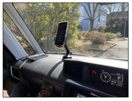
One way to supplement this first phase of the project would be to use smartphones mounted inside municipal vehicles to capture real-time images of roads across South Africa. We could install a GPS-enabled smartphone in each municipal vehicle, such as a cars or rubbish trucks. The smartphone can then be programmed to automatically take a photo at set intervals, such as every 5 seconds or every kilometre driven. The photos can then be automatically uploaded to a central server, where they can be analysed and used to update maps, track road maintenance, and identify areas that need repairs. Additionally, the real-time images can be used to monitor traffic flow, and identify potential hazards such as potholes or debris on the road.
Below is an example of a low cost image acquisition set up.
3.4 Training data
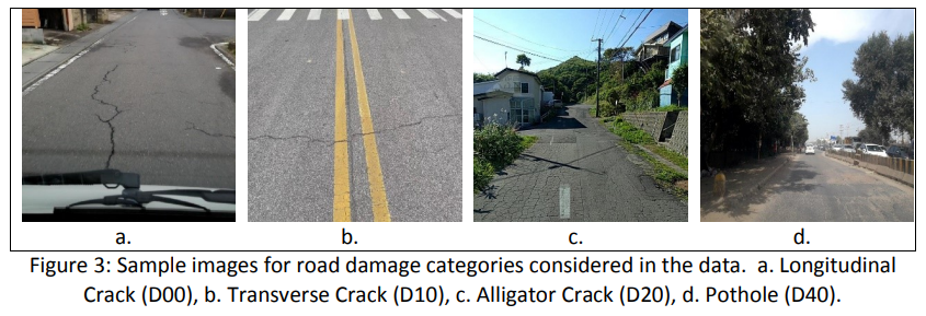
There is scope to use images of roads from the dataset of the Global Road Damage Detection Challenge (GRDDC) as training data, cutting down the cost of annotating South African data. We would still need to annotate some data in order to test our model. This could be done visually (by humans who look at the images and annotate them) or if we have some way to collect LIDAR data in South Africa of the roads, then we could use the images from the Streetview car in combination with the LIDAR data to do a
3.5 Annotation
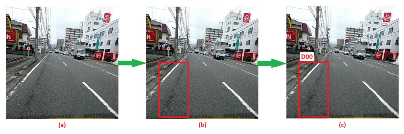
Image annotation for assessing road quality in South Africa with Google Street View imagery would involve the following steps:
Input image: The process begins with obtaining a set of Google Street View images of roads in South Africa. These images can be collected by manually navigating the Google Street View platform, or by using the Google Street View API to programmatically collect a large number of images.
Image with bounding boxes: The next step is to use annotation software to draw bounding boxes around different features of the image, such as the cracks, potholes and debris. These bounding boxes can be used to segment the image into different regions for further analysis.
Final annotated image: The final step is to label each bounding box with a class label, indicating what kind of feature the bounding box represents. For example, cracks, potholes and debris. This process is done by human annotators who are trained to identify different road features.
With these images and annotations, machine learning model can be trained to automatically identify different road features in new images and assess road quality. This information can be used to improve road maintenance and identify areas that need repairs.
We would need to create a test set and a fine-tuning set to supplement already labelled images of road condition. These test and fine-tuning sets would allow us to evaluate how well the model performs on South African roads.
3.6 Machine learning approaches
A Convolutional Neural Network (CNN) is a type of deep learning algorithm that is commonly used for analyzing image data. The CNN is trained on a large dataset of annotated images, where each image is labeled with the specific features or characteristics that it contains. The CNN uses this training data to learn to identify and extract features from new images that it has not seen before.
When analyzing images of road surfaces, the CNN is trained to recognize specific patterns and features that are indicative of damage to the road surface. For example, the CNN is trained to recognize patterns in the images that represent potholes, cracks, and other types of damage.
The CNN analyzes the images by breaking them down into smaller parts, or “features”, which it then processes through multiple layers. The first layers of the CNN are called convolutional layers, which are used to identify basic features in the image such as edges, lines, and textures. The CNN then uses these basic features to identify more complex features in the image, such as specific patterns of damage.
The final layers of the CNN are called fully connected layers, which are used to classify the image based on the features that have been identified. The CNN uses the annotated training data to learn how to classify new images based on their features. Once the CNN is trained, it can be used to analyze new images and identify features that represent damage to the road surface.